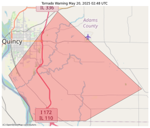
@easwatch #SevereWeather #ILwx #EAS #WEA for #DeWitt, #IL; #Logan, #IL; #Macon, #IL; #Sangamon, #IL: National Weather Service: #TORNADO WARNING in this area until 4:00 PM CDT. Take shelter now in a basement or an interior room on the lowest floor of a sturdy building. If you are outdoors, in a mobile home, or in a vehicle, move to the closest substantial shelter and protect yourself from flying debris. Check media. Source: NWS Lincoln IL ** DO NOT RELY ON THIS FEED FOR LIFE SAFETY, SEEK OUT OFFICIAL SOURCES ***
Recent searches
Search options
#ilwx
BakersRelay will be relaying severe weather from now until late tonight. If you do not wish to follow along or if I begin to overwhelm your feed please feel free to mute / block the following addresses /hashtags:
@easwatch
#SevereWeather
#ARwx
#ILwx
#KYwx
#MOwx
#MSwx
#TNwx
#VAwx
#LAwx
#ALwx
For those of you in the specified states: be safe, be prepared and listen to your local meteorologist!
#SevereWeather #ARwx #Ilwx #MOwx #KYwx #MSwx #TNwx
URGENT - IMMEDIATE BROADCAST REQUESTED
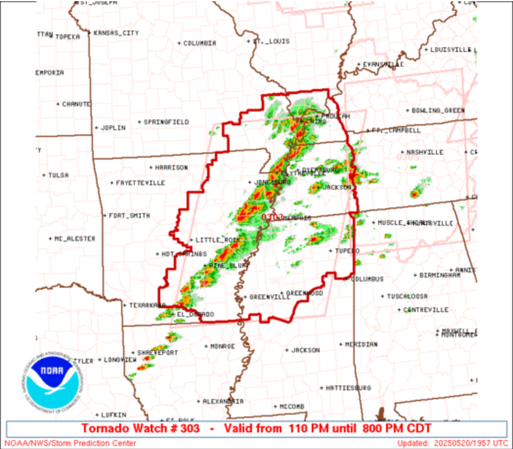
Tornado Watch Number 303
NWS Storm Prediction Center Norman OK
110 PM CDT Tue May 20 2025
The NWS Storm Prediction Center has issued a
* Tornado Watch for portions of
Eastern Arkansas
Southern Illinois
Western Kentucky
Southeast Missouri
Northern Mississippi
West Tennessee
* Effective this Tuesday afternoon and evening from 110 PM until
800 PM CDT.
* Primary threats include...
A few tornadoes likely with a couple intense tornadoes possible
Scattered large hail and isolated very large hail events to 2.5
inches in diameter likely
Scattered damaging wind gusts to 70 mph likely
SUMMARY...Thunderstorms will intensify across the watch area this
afternoon in a very moist and unstable air mass. A few supercells
are expected, capable of large hail, damaging winds, and a few
tornadoes.
The tornado watch area is approximately along and 110 statute miles
east and west of a line from 60 miles east northeast of Poplar Bluff
MO to 35 miles south of Greenville MS. For a complete depiction of
the watch see the associated watch outline update (WOUS64 KWNS
WOU3).
@easwatch #SevereWeather #ILwx #EAS #WEA for Bureau, #IL; #Henry, #IL: National Weather Service: #TORNADO WARNING in this area until 3:15 PM CDT. Take shelter now in a basement or an interior room on the lowest floor of a sturdy building. If you are outdoors, in a mobile home, or in a vehicle, move to the closest substantial shelter and protect yourself from flying debris. Check media. Source: NWS Quad Cities IA IL ** DO NOT RELY ON THIS FEED FOR LIFE SAFETY, SEEK OUT OFFICIAL SOURCES ***
@easwatch #SevereWearher #ILwx #EAS #WEA for Logan, #IL; #Sangamon, #IL: National Weather Service: #TORNADO WARNING in this area until 3:15 PM CDT. Take shelter now in a basement or an interior room on the lowest floor of a sturdy building. If you are outdoors, in a mobile home, or in a vehicle, move to the closest substantial shelter and protect yourself from flying debris. Check media. Source: NWS Lincoln IL ** DO NOT RELY ON THIS FEED FOR LIFE SAFETY, SEEK OUT OFFICIAL SOURCES ***
#ILwx #LOT #Chicago
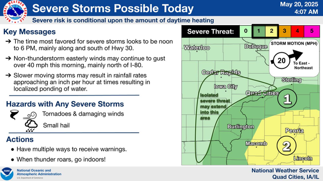
Periods of rain are expected through this evening along with a chance for thunderstorms. Some of these thunderstorms may become strong or severe south of a La Salle to Rensselaer line this afternoon into early this evening. Scattered showers and drizzle are then expected to continue through Wednesday night. Cool temperatures will continue through the weekend.
#ILwx #LOT #Chicago
The threat for a few severe storms has increased this afternoon (roughly 2-8 pm), with the main threat area south of a La Salle to Rensselaer line. All severe hazards are possible, including a few tornadoes. There is still some uncertainty regarding the location of a warm front (where the greatest severe threat will be). If the front moves farther north, severe chances would increase towards/north of I-80.
@easwatch #SevereWeather #ILwx #EAS #WEA for Johnson, #IL; #Union, #IL: National Weather Service: #TORNADO WARNING in this area until 2:00 AM CDT. Take shelter now in a basement or an interior room on the lowest floor of a sturdy building. If you are outdoors, in a mobile home, or in a vehicle, move to the closest substantial shelter and protect yourself from flying debris. Check media. Source: NWS Paducah KY ** DO NOT RELY ON THIS FEED FOR LIFE SAFE
#SevereWeather #MOwx #ILwx #INwx #KYwx
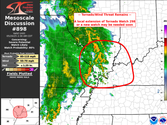
Mesoscale Discussion 0898
NWS Storm Prediction Center Norman OK
0107 AM CDT Tue May 20 2025
Areas affected...far eastern Missouri...southeast
Illinois...southwest Indiana...and western Kentucky
Concerning...Severe potential...Watch likely
Valid 200607Z - 200730Z
Probability of Watch Issuance...80 percent
SUMMARY...Wind damage and QLCS tornado threat may persist east of Tornado Watch 298. An extension in space of the existing watch or a new watch may be needed.
DISCUSSION...A long-lived linear MCS continues to move east across Missouri this morning. This MCS has a history of producing sporadic wind damage along with transient to slightly longer lived low-level circulations/QLCS tornadoes.
The environment along the path of the MCS Monday evening was unstable and highly sheared. SPC mesoanalysis shows the environment ahead of the MCS remains highly sheared -- 40-50 knots effective deep-layer shear -- and remains unstable -- with mixed-layer CAPE between 1000-2000 J/kg. SPC Mesoanalysis also shows that this region is a relative minimum in convective inhibition, which would support a continued wind threat/QLCS tornado threat.
Either a local extension of Tornado Watch 298 or a new watch will likely be needed within the next hour.
#ILwx #LOT #Chicago
Rain will spread over the area late this evening and continue through much of Tuesday. The rain could be heavy at times and include some embedded thunderstorms. Additional shower chances are found through midweek before conditions quiet down closer to the weekend, though below normal temperatures will continue.
#ILwx #LOT #Chicago
Expect rain, heavy at times, with some embedded thunderstorms later tonight through the day tomorrow. The heavy rain may result in localized flooding, and may also lead to limited visibility and slowed driving. Use extra caution when driving in heavy rain and never attempt to drive on flooded roads. It will also be windy with gusts up to 35-40 mph from the east on Tuesday.
#ILwx #LOT #Chicago
There is a chance for a few showers or sprinkles today, mainly south of Interstate 80. Periods of rain will develop tonight and continue into Tuesday morning. There will also be a chance for a few thunderstorms. Scattered showers or drizzle will continue Tuesday night and Wednesday. It will also be breezy today and tonight and windy on Tuesday with gusts to 40 mph possible, mainly north of Interstate 80. Large temp
#ILwx #LOT #Chicago
Aside from a stray sprinkle or two, Monday looks to be mostly dry. Rain chances will increase late Monday night with periods of soaking rainfall, some locally heavy, and a few storms to prevail through Tuesday. Spotty lingering showers are expected through Wednesday before dry conditions return with otherwise seasonably cool temperatures.
#ILwx #LOT #Chicago
A lake-enhanced cold front will result in falling afternoon temps, particularly within about 50 miles of the lake. Rain chances increase late Monday night into Tuesday, with periods of soaking, locally heavy, rainfall at times. Intermittent showers/drizzle will linger through Wednesday.
#ILwx #LOT #Chicago
A lake enhanced cold front will result in cooling temperatures Sunday afternoon, particularly near the lake. Rain chances will return Monday through Wednesday with highest rain and storm chances Monday night and Tuesday. Otherwise, seasonably cool conditions can be expected this week especially along Lake Michigan.
"Laurel County resident Chris Cromer said he got the first of two tornado alerts on his phone around 11:30 p.m. or so, about a half-hour before the tornado struck. He and his wife grabbed their dog, jumped in their car and scrambled to the crawlspace at a relative’s nearby home because the couple’s own crawlspace is small.
“We could hear and feel the vibration of the tornado coming through,”" #kywx #tornado #kentucky #missouri #StLouis #mowx #ilwx #noaa #nws
https://apnews.com/article/tornado-weather-thunderstorms-great-lakes-22395202a65b0c37cc06c541ea772172


