OpenStreetMap turns 21! Happy Birthday! CoMaps would not be possible without all the OSM people, the community is amazing!
https://wiki.openstreetmap.org/wiki/OpenStreetMap_21st_Anniversary_Birthday_party

OpenStreetMap turns 21! Happy Birthday! CoMaps would not be possible without all the OSM people, the community is amazing!
https://wiki.openstreetmap.org/wiki/OpenStreetMap_21st_Anniversary_Birthday_party
Hey, who wants to go to the #cinema in #Hanover? If you think that sounds like a good idea, don’t use a #map app that automatically scrapes #Wikipedia for locations to find one – unless you’re fine with watching a film on #AppleTV instead. Because where once was the historic cinema Palast Theater is now an #AppleStore. 
(The cinema shut down before #OpenStreetMap even existed, so don’t blame them!)
I have a question about mapping tools that can help with local activism/organizing/campaigns.
I am currently using Google Maps to plot individuals at various addresses. (Easy to import data to the map, I can share this with others, etc.)
But there is a problem. If there are multiple individuals with the same address, Google Maps only puts one pin at a given address...and no additional symbology/color to show you that more than one pin is plotted...even if you hover over it or click on it...only the top pin is shown.
What other mapping tools (that I can easily share with others) can properly display multiple pins at a given address?
(This question also opens the door to other features...can field operatives make updates in real time and share to a central data source/server?...and more and more.)
As always, for grass-roots stuff...free is best, lowest cost is next best.
Feel free to boost.
Thanks in advance!
I seem remember a #Mapping (Software Development) related #Event in Austria. I believe it was an #OpenSpace. I missed it several years and now can't remember how it was called.
Can someone tell me the name?
Found: It's the @comocamp 
(thanks to @kober for the pointer)
GitHub - mdornseif/osm-treewarden: Bäume in OSM kuratieren. https://github.com/mdornseif/osm-treewarden #OpenStreetMap #OpenSource #typescript #mapping #GitHub #tree

Map Area Showcase
Share a screenshot of your favorite spot on the map, along with its coordinates! An intricate city, a hidden natural wonder, or something totally unique, tell us what makes this place special! Let's see your top picks!
I have a few photo books to make, of course with maps. Do people watch live streams of that sort of thing?
We are now mapping Project 3!  Priority Project: #23834 https://tasks.hotosm.org/projects/23834
 https://tinyurl.com/UNMFAOprojMauritania
 Join our #ValidationFriday Mappy Hour this Friday, 1 August!
Experienced and aspiring ones are welcome! https://osmcal.org/event/3872/
More updates in the coming days!
Become a UN Mapper! 
#UNMappers x #FAO mapping updates 
As of 28July, we have completely mapped and validated Project 2 

We have added about:
 3,203 km of waterways and
  904 km² of farmland areas
 How does FAO use the #opendata we generated?
Check their updates from last week's #MappyHour 
 https://youtu.be/yLqTjataZFY
 HUGE thank you to our volunteers and top contributors! A record of 800+ tasks mapped in 2weeks
Nous réfléchissons depuis quelques mois à mettre en images et en scène une petite histoire radicalement humaniste. Quoi de mieux pour élaborer quelques recettes lumineuses qu'une biscuiterie souterraine ?
#residence #spectacle #dessin #mapping #WorkInProgress #projections #creations #ombres
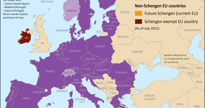
And here's our article covering what's changed for the #SchengenArea #map over the last five years, with the addition of #Croatia, #Bulgaria, and #Romania creating an uninterrupted land bridge to #Greece for the first time: https://www.polgeonow.com/2025/07/schengen-new-countries-changes-2023-2024-2025-next-future.html
#geography #EuropeanUnion #maps @geography @geopolitics #mapping #EU #Schengen #geopolitics #Europe #SchengenExpansion
En.osm.town is an independent Mastodon server for people active in the OpenStreetMap community.
This server has been operating since 2018.
You can find out more at https://en.osm.town/about or contact the admin @compass

It doesn't really show up on the scan but I love that this sender used glitter to illustrate their dream! Lovely.
#Dreams of a #City #postcard 6678: left 18 September 2024 at SW. corner of Grand & Ashland. Front http://www.instagram.com/p/DMdZRuNOIrj & back http://www.instagram.com/p/DMdZWsoOxN7
More about my ongoing large-scale #interactive #publicart project at http://artistsonthelam.blogspot.com/p/dreams-of-city.html
UN Mappers x FAO mapping updates
As of 22 July, we have mapped 80% and validated 44% of Project 2
We thank the 73 mappers who have contributed their time to map with us
 Shoutout to our top contributors for the past week
Map with us and become a UN Mapper! Priority Project: #23833 https://tasks.hotosm.org/projects/23833 https://tinyurl.com/UNMFAOprojMauritania
Stay tuned for more updates!
Anyone interested in using, contributing to or reviewing a Roman Road layer for #openstreemap?
https://umap.openstreetmap.de/en/map/roman-roads_101209#7/51.155/0.236
#RomanRoads #mapping #roman #romanempire #römerzeit #römer #römerstraße
Work for the Smithsonian!
--
https://trustcareers.si.edu/en/postings/560a4d08-11ef-45a3-a8bf-cc550f70c8fd
--
#GIS #spatial #mapping #twoyearfixed #smithsonian #job #jobopening


 Roy Phillips

 Greg Cocks