#AZPol #Arizona #GOP #GroundWater
From AP.com: Arizona's rural groundwater deal stalls as legislative session nears end
https://apnews.com/article/arizona-groundwater-pumping-7a340307802e4b1e77567c2e393a20e1

#AZPol #Arizona #GOP #GroundWater
From AP.com: Arizona's rural groundwater deal stalls as legislative session nears end
https://apnews.com/article/arizona-groundwater-pumping-7a340307802e4b1e77567c2e393a20e1
Inter-Basin Groundwater Flow In West-Central Florida
--
https://doi.org/10.1016/j.jhydrol.2025.133423 <-- shared paper
--
https://fl.water.usgs.gov/floridan/intro.html <-- shared USGS overview page, Floridan Aquifer System Groundwater Availability
--
“HIGHLIGHTS
• The regional pattern of IGF in west-central Florida is dominated by the characteristics of the Upper Floridan Aquifer.
• IGF plays a major role in the available water for partitioning and watershed aridity index.
• Groundwater pumping affects IGF, and the change in IGF counteracts the human impact on available water..."
#GIS #spatial #mapping #groundwater #spatialanalysis #spatiotemporal #Florida #USA #waterresources #waterquality #watersecurity #regional #model #modeling #HSPF #MODFLOW #geology #sedimentology #hydrogeology #aquifer #runoff #discharge #watershed #precipitation #climate #aridity #index #pumping #humanimpacts #anthropogenic #watersupply


From today's Next Door-
"The Los Alamos National Laboratory plans to begin large releases of radioactive tritium gas any time after June 2, 2025. The only roadblock to the Lab’s plans is that it needs a “Temporary Authorization” from the New Mexico Environment Department to do so."
We urge citizens to sign a petition to NMED at :
https://actionnetwork.org/petitions/petition-to-deny-lanls-request-to-release-radioactive-tritium-into-the-air
nukewatch.org

#CSIRO is advertising a number of #groundwater jobs right now - some ongoing, some fixed-term. Check them all out here:
https://jobs.csiro.au/search/?createNewAlert=false&q=groundwater
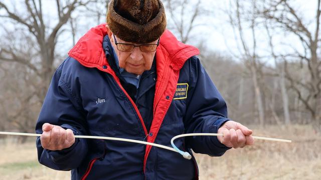
"To be clear, science does not support dowsing to find water. Studies have shown dowsing is no better than random chance.
"The U.S. Geological Survey says dowsers are successful because in most areas water is so prevalent it would be hard to drill a well and not find water."
https://www.mprnews.org/story/2025/05/12/minnesota-dowser-in-demand-despite-no-scientific-proof
Groundwater Pumping Is Contributing To The Subsidence Of Major U.S. Cities
--
https://www.nytimes.com/interactive/2025/05/08/climate/sinking-cities-us-causes-groundwater.html <-- shared media article
--
https://doi.org/10.1038/s44284-025-00240-y <-- shared paper
--
#water #groundwater #subsidence #city #cities #spatialanalysis #spatiotemporal #engineeringgeology #engineering #risk #hazard #pumping #overpumping #waterresources #USA #America #sinking #infrastructure #damage #cost #economics #repais #mitigation #sealevelrise #flood #flooding #foundations #urban #remotesensing #earthobservation #satellite #elevation #measurement #change #vertical #movement #geology #soils #model #modeling #prediction #waterresources #farming #agriculture #watersupply #industry #well #riskassessment #landuse #monitoring #management #utilities #growth #population #demographics #construction #sprawl


Over A Third Of Groundwater In USA Public-Supply Aquifers Is Anthropocene[sic]-Age And Susceptible To Surface Contamination
--
https://doi.org/10.1038/s43247-022-00473-y <-- shared paper
--
#GIS #spatial #mapping #surface #contamination #USA #waterquality #waterresources #groundwater #publicsupply #Anthropocene #potable #waterwell #municipal #watersupply #residential #age #aquifers #regional #landsurface #contamination #spatialanalysis #spatiotemporal #holocene #publicsafety #pumping #sustainability


https://www.europesays.com/2010346/ Iran Faces Widespread Land Subsidence Amid Escalating Water Emergency #agriculture #ClimateChange #Conflicts #drought #earthquake #GroundWater #Iran #IranSinkholes #IranWaterCrisis #LandSubsidence #WaterBankruptcy

Why Geological Maps Are The Best Investment You’ve Never Heard Of - Investments In Geological Mapping Paid Off Big Time For Americans.
--
https://www.zmescience.com/science/geology/why-geological-maps-are-the-best-investment-youve-never-heard-of/ <-- shared opinion piece
--
https://profession.americangeosciences.org/reports/geological-mapping-economics/ <-- shared technical cost-benefit analysis
--
https://www.geosociety.org/GSA/gsa/positions/position3.aspx <-- shared 2003 GSA appraisal
--
[I am, of course, biased in this regard, but I also like well-presented metrics – and use cases being met are my favourite!]
#geology #value #cost #mapping #cartography #cartographic #USA #costbenefit #geologicmapping #metrics #usecase #fedscience #appliedscience #engineeringgeology #spatial #GIS #construction #resources #naturalresources #engineering #risk #hazard #naturaldisasters #payoff #investment #massmovement #groundwater #waterresources #water #hydrology #rareearth #minerals #mining #oilandgas #exploration #underground #money #economics #publicgood #publicvalue #investment


#Fukushima Now – Current State of Post-Accident Operations at Fukushima Daiichi Nuclear Power Station (August 2024 to January 2025)
by Citizens' Nuclear Information Center · Published April 2, 2025 · Updated April 2, 2025
By Matsukubo Hajime
Excerpt: State of #ContaminatedWater
"Contaminated water countermeasures at #FukushimaDaiichi #NuclearPower Station (#FDNPS) can be broadly divided into three areas: 1) Reduction of #groundwater flowing into buildings, 2) Reduction of #ContaminatedWater flowing into the sea, and 3) Reduction of the toxicity of contaminated water.
"Countermeasures implemented to reduce water inflow into the buildings are, from higher elevations downward, (A) Pumping up groundwater at the groundwater bypass and releasing it into the sea (953,611m3 up to February 10, 2025), B) Installation of a frozen earth barrier (on-land water barrier, total length roughly 1,500m) surrounding FDNPS Units 1-4, C) Pumping up water at the subdrains and releasing it into the sea (1,801,404m3 up to February 9), and D) Paving of the site with asphalt to suppress permeation of rainwater into the soil. Measures to prevent the discharge of contaminated water into the ocean include A) Groundwater leakage prevention by a steel water barrier on the sea-side and B) Pumping up of groundwater dammed up behind the sea-side water barrier from the well points and groundwater drains. Due to these measures, the volume of contaminated water discharged, 540m3/day in May 2014, fell to 80m3/day in FY2023, and was below 100m3/day in FY2024.
"In the reduction of the toxicity of contaminated water, cesium and strontium are removed, and after the removal of impurities using a reverse osmosis (RO) membrane, the multi-radionuclide removal equipment (ALPS – Advanced Liquid Processing System) then removes 62 radionuclides [NOT COMPLETELY!!!]. The water is then stored in tanks (containing 1,297,190m3 as of January 30, 2025. However, due to past equipment #malfunctions and operational policies, around 64% of the stored water exceeds the notification concentration).
"Oceanic release of the ALPS-treated contaminated water began on August 24, 2023, a total of 78,285m3 being released in ten batches by January 2025. Table 2 shows the amounts released in each release and the total amount of tritium released. The concentration is gradually rising. One further release is scheduled during FY2024. In addition, roughly 15,720m3 of water remain in buildings, and a further 8,946m3 of strontium-treated water, etc., 5,644m3 of water treated by RO, and 9,463m3 of concentrated wastewater, etc. also exist onsite."
Read more:
https://cnic.jp/english/?p=8272
#FukushimaIsntOver #WaterIsLife #PacificOcean #TEPCOLies #FukushimaNuclear #RethinkNotRestart #RadioactiveContamination #HormesisIsBullShit #Bioaccumulation
One month left to provide feedback on our preprint "Rainfall recharge thresholds decrease after an intense fire over a near-surface cave at Wombeyan, Australia."
We are keen for some constructive feedback to improve the paper :)
https://egusphere.copernicus.org/preprints/2025/egusphere-2025-84/
https://www.alojapan.com/1231185/groundwater-anomaly-related-to-ccs-co2-injection-and-the-2018-hokkaido-eastern-iburi-earthquake-in-japan/ Groundwater Anomaly Related to CCS-CO2 Injection and the 2018 Hokkaido Eastern Iburi Earthquake in Japan #CarbonIsotopes #CCSCO2Injection #Groundwater #Hokkaido #HokkaidoEarthquake #HokkaidoNews #news #radiocarbon #北海道 Introduction There is a global consensus that some form of carbon capture and storage (CCS) technology is necessary to reduce CO2 emission associated with fossil fuel combustion into the atmosphere (IPCC Special Report, 2005). …

#ClimateChange #GroundWater #Agriculture
From AP.com: Earth’s storage of water in soil, lakes and rivers is dwindling. And it’s especially bad for farming
There's only one month left for open comments on our current preprint, which looks at rainfall recharge thresholds before and after a fire.
We are very interested to get some community input! If you are interested in #groundwater #waterResources #karstHydrology #hydrology, please check it out.
https://egusphere.copernicus.org/preprints/2025/egusphere-2025-84/
Stories from #TheAmazon, #Kenya and #Zimbabwe
#WorldWaterDay: 3 stories of #resistance and #restoration from around the globe
Kristine Sabillo, 21 Mar 2025
"More than 2 billion people around the world live without access to safe drinkable water, as rivers, #groundwater, lakes and #glaciers face continued threats of #pollution and overexploitation due to #urbanization, #EnvironmentalDestruction, and #ClimateChange .
"This World Water Day, #Mongabay looks back at some of its coverage from 2024 on how local communities are trying to protect the world’s dwindling water resources."
https://news.mongabay.com/short-article/world-water-day-3-stories-of-resistance-and-restoration-from-around-the-globe/
#WaterSecurity #WaterIsLife #RiversAreLife #OceansAreLife #Wetlands #Marshes #Rivers
Groundwater recharge at 800-year low in Western Australia, posing risks https://phys.org/news/2025-03-groundwater-recharge-year-western-australia.html
 New preprint
Hydrology and cave (and cave hydrology!) enthusiasts may enjoy this preprint just posted today for community review in the #EGU journal #HESS. Led by former #UNSW student, Christina Song, with @Andbaker and myself, we looked at recharge thresholds (amount of precipitation needed for recharge to occur in a cave), and how they changed after a fire.
https://egusphere.copernicus.org/preprints/2025/egusphere-2025-84/
The preprint is open now for community discussion, and will be accepting comments until 23 April.
#Climate #California #GroundWater
Even in wet years, wells are still dry. Why replenishing California’s groundwater is painfully slow
Linking climate to groundwater recharge – the view from underground
I've been invited to present to the International Association of Hydrogeologists, Australian New South Wales section, on Tuesday 11th March. If the title above sounds interesting, details are below, non members are welcome and the event is hybrid. You can read more at:
http://andy-baker.org/2025/02/25/linking-climate-to-groundwater-recharge-the-view-from-underground/


 Greg Cocks